Henri’s Impact on Seacoast Changes as Track Shifts West
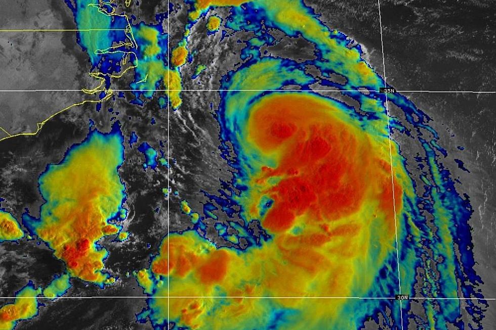
The track of Tropical Storm Henri has shifted west changing the impact the storm will have on the Seacoast.
Henri will be a category one hurricane when it makes landfall in eastern Long Island with sustained winds of over 70 mph early Sunday morning. The storm will track north towards western Massachusetts where it will weaken into a tropical depression by early Monday morning.
Henri will then head across southern Vermont Monday afternoon and into New Hampshire and southern Maine by Tuesday morning where it will essentially be a strong low pressure area, according to National Weather Service meteorologist Nikki Becker.
There is also a chance the storm could stall in New York's Hudson Valley for a time which could prolong the storm's impact.
Henri's Impact on the Seacoast
The Seacoast will be affected by Henri starting Sunday and lasting into Tuesday with showers and bands of heavy rain. The humidity already in place gives the atmosphere plenty of fuel for rain.
"It's muggy out. It's going to muggy Sunday. We have on shore flow. Basically we have all that moisture being invected onto land," Becker told Seacoast Current.
The Seacoast will be in the northeast sector of the storm on Sunday afternoon which is traditionally the most active area of the storm even though it will still far away, according to Becker. That sets up the possibility of isolated severe storms in the Seacoast.
Sustained hurricane or even tropical storm strength winds will not be part of Henri's impact on the Seacoast, according to Becker, who expects winds to top out at 35 mph with some higher gusts.
Sunday's full moon brings the potential for astronomical high tides even without a tropical storm. With high water levels already in place minor coastal flooding is a concern. There will also be a moderate risk of rip currents along the beaches on Sunday with wave heights of 4-5 feet.
Preparing for the Worst
Utilities are prepared for the worst as Henri approaches. Unitil has lined up additional third party crews to help with restoration efforts. It open its System Emergency Operations Center Sunday in order to coordinate its response efforts, should outages occur.
The utility recommend customers prepare by checking and making an inventory of the
flashlights and fresh batteries, a battery-operated radio and clock, bottled water, canned foods and a manual can opener.
Eversource is making similar preparations but also reminded pet owners to make sure to have food and water for them as well. The company also said to watch your pets if they have to go outside during an outage as hazards that are not immediately visible like wires tangled in trees could be present.
Take a few minutes to secure garbage cans, outdoor toys, and lawn furniture by Saturday night. Keep your cell phone charged, in case of power outages. Those who live along tidal waterways that flood "in every storm" may need to park their car on higher ground this weekend.
New Hampshire Homeland Security and Emergency Management Director Jennifer Harper urged those who are taking part in outdoor activities to keep an eye on the forecast.
"Sunday is too late to be prepared. If you're camping, if you're hiking, if you have outdoor activities, please pay attention to the weather. We don't want to be sending crews to do swift water rescues or mountain rescues," Harper said.
Massachusetts Department of Conservation and Recreation has canceled reservations at all its campgrounds Saturday through Monday, according to a tweet. Facilities will reopen as conditions permit and any damage has been assessed.
Meteorologist Dan Zarrow contributed to this report
Contact reporter Dan Alexander at Dan.Alexander@townsquaremedia.com or via Twitter @DanAlexanderNH
25 True Crime Locations: What Do They Look Like Today?
More From Seacoast Current


