Henri Will Bring Periods of Heavy Rain to the NH Seacoast
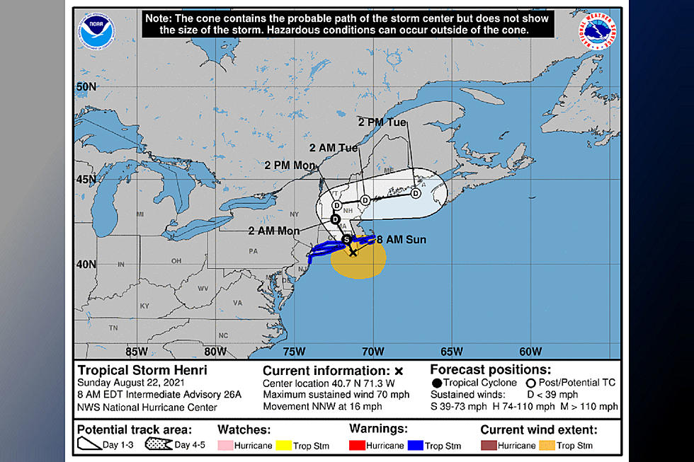
The biggest threat to the Seacoast from Tropical Storm Henri is from heavy rain as the storm approaches and then lingers over northern New England on Monday.
With sustained winds of 70 mph Henri is expected to make landfall late Sunday morning near Block Island, Rhode Island and track northwest into Connecticut, Massachusetts and southern Vermont.
Ahead of the storm are feeder bands of heavy rain in Massachusetts pushing northward that will affect the Seacoast late in the morning, according to National Weather Service Meteorologist Donnie Dumont.
"You'll get some pretty torrential downpours through midday and then it will be more sporadic heavy tropical downpours through the rest of the afternoon," Dumont told Seacoast Current.
Winds will pick up out of the northeast that will cause rough surf and a moderate risk of rip currents right along the coast
"People should not be jumping in the ocean water," Dumont said,
When Henri reaches southern Vermont early Monday it will slow down and even stall as it begins to make the turn to the northeast to head across New Hampshire
"It's just going to spin there with more showers expected through Monday. Then the remnant of the circulation isn't going to be a wind threat but we could get another heavy rain event Monday night as Henri goes over the Seacoast. Then it should be out of here and an after thought," Dumont said.
New Hampshire Homeland Security and Emergency Management will open the state emergency operations center at noon on Sunday.
“We are taking this storm seriously and you should, too,” said Director Jennifer Harper. “People need to monitor changing local weather conditions and
know what to do if an emergency occurs."
Contact reporter Dan Alexander at Dan.Alexander@townsquaremedia.com or via Twitter @DanAlexanderNH
LOOK: Here are the 50 best beach towns in America
More From Seacoast Current


