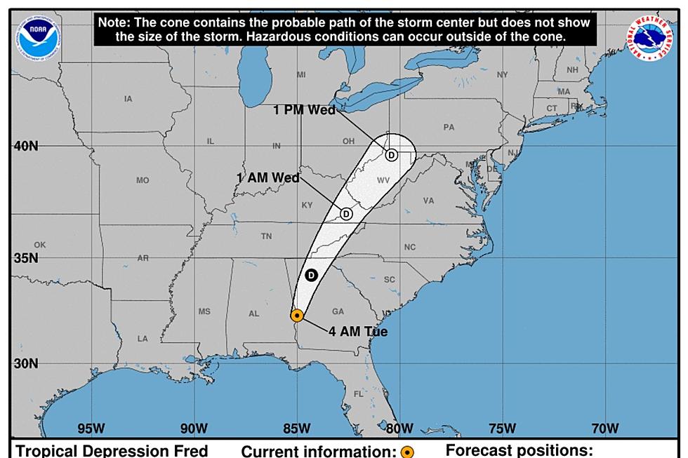
Remnants of Fred Make for a Wet Thursday on the Seacoast
The remnants of Tropical Storm Fred will leave the Seacoast wet on Thursday and all eyes are on the track of the next system name Henri.
A Flash Flood Watch goes into effect Thursday morning with the potential for rain to fall at the rate of an inch per hour in areas away from the immediate coast.
"For the Seacoast we're expecting an inch to an inch-and-a-half of rainfall with lesser amounts right along the coastline," National Weather Service Meteorologist Michael Clair told Seacoast Current.
Some showers Wednesday evening were part of Fred but the steadiest, heaviest part of the storm will arrive by late Thursday morning, according to Clair.
"Be aware of the local weather forecast and know what to do if flooding does occur,” Dover Fire Chief Paul Haas said. “If flooding occurs, get to higher ground immediately."
Haas also said residents should check drains and gutters to ensure they are clear of debris before heavy rains begin.
Next Up: Henri

The National Weather Service is also keeping an eye on Tropical Storm Henri (on-REE') which could put the Seacoast into a cone although it's four days away, according to Clair.
The first impact of Henri on the Seacoast will be waves kicking up on Sunday that could cause life-threatening surf and rip currents, Clair said.
"There's a lot that can happen between now and then. We'll see how it evolves over the next few days. There's a 50 percent chance it stays out to see based on that cone track. We're definitely watching it closely," Clair said.
Contact reporter Dan Alexander at Dan.Alexander@townsquaremedia.com or via Twitter @DanAlexanderNH
LOOK: The most expensive weather and climate disasters in recent decades
Gallery Credit: KATELYN LEBOFF
More From Seacoast Current